Why Some Villages Gather Around a Crossroads
Why some villages gather around a crossroads: learn how routes, terrain and everyday meeting places shape settlement patterns without explaining every village.
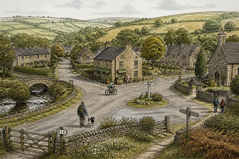
A common mistake is to treat a crossroads as the reason a village exists. It may instead be the place where paths, buildings and local services accumulated over time, while the original settlement grew from other needs. Understanding why some villages gather around a crossroads means looking at routes, terrain and ordinary meeting points together—not searching for one universal cause.
Use a week of short observations to read the settlement in that way. You do not need a formal survey: an Ordnance Survey map, a notebook and a few walks through the village are enough to compare what the map suggests with what people still do there.
What does the crossroads connect?
Start with the roads and paths rather than the buildings. On a paper map or the OS Maps app, trace the routes entering the village from each direction. Note where they lead: another settlement, farmland, a river crossing, a station, a market town or a route up to higher ground.
Then follow those lines on foot, choosing public paths and pavements. A road that looks important on a map may now be quiet, while a narrow lane still carries people between homes, a school or a shared facility. Look for changes in width, surface and direction. A junction may bring together routes that were formed at different times, rather than marking a single planned centre.
On the first day, make a simple sketch with the main routes and visible landmarks. Add hedges, streams, steep slopes and bridges. These features can explain why travellers met at one point, or why a seemingly obvious route bends around the settlement instead of crossing it.
How does the land shape where people build?
Return on the second day and pay attention to the ground. Villages may cluster on a dry ridge, beside a dependable crossing, or along a slope that offers access to fields without sitting on wet ground. A crossroads can be convenient, but the land around it may be unsuitable for houses, or the route may once have been difficult in poor weather.
Notice where buildings stop. A stream, flood-prone ground, a sharp rise or a broad field may leave homes concentrated on one side of the junction. The settlement can therefore look centred on the roads while its shape is really constrained by terrain and land use.
Do not infer the past from a single visible feature. A modern road may have been widened or redirected, and a new housing edge can shift the apparent centre. Mark what you can observe, then keep possible explanations separate from facts you have checked.
Which everyday places make a junction feel central?
On the third day, look for places where people have a reason to pause: a shop, pub, school gate, village hall, churchyard entrance, post box or sheltered bench. Check where these sit in relation to the routes. Some may gather at the crossroads; others may be spread along a main street or grouped around a green.
The distinction matters. A junction can be a point of passage without being a social centre. A shop beside it may draw brief visits, while a hall set back along a side lane may host the gatherings that give residents a stronger sense of a shared centre. Opening hours, accessibility and changing services also affect which places remain useful.
Imagine a village with a crossroads beside a former shop, while its active hall stands near the school on a quieter lane. A visitor might call the junction the centre from the map alone. After walking both routes and noticing where people wait, meet or attend local activities, that visitor could describe two centres serving different purposes instead.
How can you read the village over a week?
Keep the observations manageable. Visit at different ordinary times, not just when a special event is under way. Record the day and conditions, since a school run, market morning or wet spell can change which routes and meeting points are busy.
- Day one: Trace the roads and public paths on a map; note where each route goes beyond the village.
- Day two: Walk the approaches and mark slopes, streams, bridges, hedges and changes in road surface.
- Day three: Locate shared places and services; note whether they sit at the junction, along a route or apart from both.
- Day four: Revisit at a different everyday time and record which paths appear in use, without assuming one visit represents a usual pattern.
- Day five: Compare the sketch with a current map and, where available, older maps at a local library or county record office. Treat differences as clues, not proof of a single cause.
- Day six: Ask a resident or local-history group what they know about a building, crossing or route. Separate remembered accounts from what a map or visible feature can establish.
- Day seven: Write a short account that identifies several influences and states what remains uncertain.
What questions help explain the pattern?
Does every crossroads village have a central square?
No. Some have a green, market space or cluster of services, while others have only a road junction and buildings strung out along the routes. The form depends on local history, available land and how the settlement developed.
Can a village centre move over time?
Yes. New housing, changed traffic routes, a closed shop or a relocated service can make another place more useful for daily life. The old junction may remain visually prominent even after activity shifts elsewhere.
How do terrain and routes work together?
A route may converge at a bridge or a gap between hills because the landscape channels movement. Yet buildings may cluster on the nearest dry or level ground, so the most important meeting point and the largest group of homes need not coincide.
How can I tell observation from local explanation?
Record visible details separately from what someone tells you or what you infer. For example, “the road crosses the stream here” is observable; “the village began because of the crossing” needs supporting evidence.
Why does one pattern never explain every village?
Settlement form is usually layered. Routes may connect farms and neighbouring places; terrain limits where building is practical; shared services draw people to certain spots; and later changes alter the balance. A crossroads can be one strong influence without being the starting point or the present-day centre.
Local records can add context when you want to go further. Ask a library or county record office about historic maps, tithe maps or parish records, and check what each document covers before drawing conclusions. Map symbols and boundaries vary by period, so compare like with like rather than treating one old sheet as a complete account.
For a useful explanation of why some villages gather around a crossroads, finish with a modest claim: describe the routes, land and meeting places you can identify, then say how they appear to relate. That gives readers a grounded account while leaving room for the parts of the village’s history that the landscape alone cannot reveal.